
ROUTE LIRES – FARO FISTERRA
FRIDAY, MAY 30
In this path of unique natural diversity this last stage could not be missed. From Lires to Fisterra a succession of imposing cliffs and pristine beaches are emerging one after another on a hard coast, where stories continue to appear at each point such as the Cason, a shipwreck that caused a massive exodus of the entire region. Unique landscapes that will bring us closer to the Faro de Fisterra, the culmination of this adventure and the end of Lighthouse Way, a trail that will take you a long time to forget.
Difficulty HIGH
21.9 kilometers
9 hours
+- 1100 m slope


Make your reservation for the GWF Camiño dos Faros Program


This last stage of our Camiño dos Faros begins in Lires, a village with a lot of charm and already accustomed to the pilgrim, which passes between granaries and restored cottages with pleasure. The offer of accommodation is wide and varied, so we recommend you to spend a few days.
Lires was always the example of common work, a neighborhood that already demonstrated that union in the late 60s, as this old documentary shows, in which you see the entire process performed for the installation of water. In Lires we find some of the first rural houses in Spain. Casa Lourido and Casa Raúl, which continue to this day, joined in 1968 the program of the Ministry of Tourism called Holidays in Farm Houses, the germ of the current rural tourism.
The Church of San Estevo was built in the seventeenth century on the remains of a previous one, closer to the estuary. From the bridge leaves the Camino de Santiago on the left, but we continue along O Camiño dos Faros, through the cemetery on the right to discover this natural paradise: the Lires Estuary.
The Estuary of Lires is the smallest in Galicia and is formed at the mouth of the Castro River on Nemiña Beach. From the bridge we begin the comfortable walk through this natural paradise, among the shadows of the trees that grow on its banks. Upon arriving at the fish farm, these small streams join the Castro River, more abundant, to form the estuary. This environment is the perfect habitat for a good number of birds, especially seagulls, cormorants and herons, who find easy food among the remains that turn to the sea, in addition to having a quiet environment and far from the presence of man.
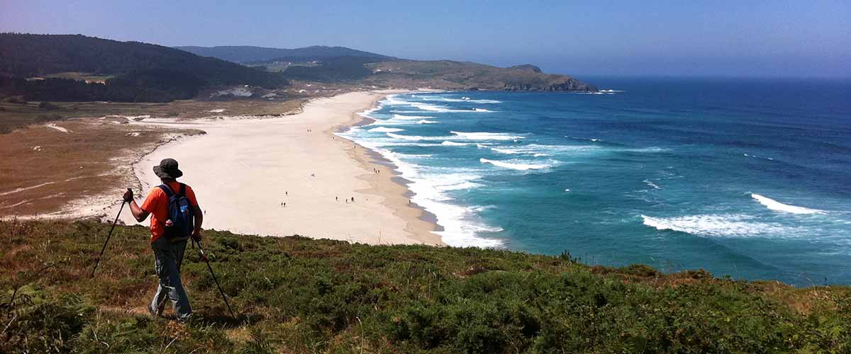
The tides are modifying the landscape totally twice a day, and every time we pass our sensations are different. Thus we arrive at Lires Beach, a small and quiet sandy area that forms on this side of the estuary. See if it is small that at the mouth you can cross in summer at low tide with water by the ankles. The whole complex seen from there is one of the best views of this Camiño dos Faros: the Nemiña Beach, with its thousand faces, the large dune covered with vegetation and the entire mouth, which also moves from year to year. Find your corner and fill your senses …
From Lires Beach to Rostro Beach, O Camiño dos Faros enters a section through which we will see the coast of Canosa, formerly called Ribeira de Calvoa, from all perspectives, with the cliffs of Punta Lagoa and Mexadoira as main protagonists. It is a complicated stretch of the trail, do not get into strong wind or rain conditions, but look closely at the arrows and you will not have any problems.
It’s amazing … and very difficult to describe. The cliffs fall vertically on a base of rocks that, with the sea breaking and the red granite rock, confer a very peculiar landscape. At the end of the cliff, a stream that descends from the mountain falls on the round stones of the coast, forming a small waterfall. Be careful and do not get too close to the edge or go down to take the picture of the waterfall, because all these rocks are very slippery and it is very difficult to hold the balance. When we arrive and turn around, it is when we really admire, without any danger, all the beauty of this place. Again a unique wild section of Camiño dos Faros … and unknown to most.
We leave Mexadoira and we see the immensity of Rostro Beach, another wild wonder of this Death Coast. An ode to the sea, saltpeter and pure air … a complete luxury for the senses in these almost two kilometers of beach. Open to the Atlantic Ocean, the constant wind that hits there during a good part of the year has formed an extensive dune system, with important heights and full of vegetation, which at some times of the year gives it a color that covers everything.
We cross the almost two kilometers of Rostro Beach along the seashore, without hurry and enjoying every step of paradise that we have so close. Listen to the noise of this sea that in few places you will hear roar as it does here … O Camiño dos Faros, a sensation at every step.
We climb the beach and the panoramic view from Rostro Point is impressive. We have to be careful not to get too close and we will contemplate this wonder in all its splendor: cliffs that plummet towards the ocean, with Punta Castelo in the background, looking defiant. Right here, in the midst of this explosion of life, there was one of the events that changed the life of a whole region for a few days. On the morning of December 5, 1987, the Panamanian flag ship Casón was sailing 15 miles from Fisterra with 31 crew, all of Chinese nationality, with a cocktail load of 1100 tons of flammable, toxic and corrosive chemicals bound for Shanghai. In the middle of a strong storm, it suffers a movement of the storage material that causes a serious fire on board.
The captain, the only connoisseur of the actual cargo, orders to leave the ship. In the midst of smoke and toxic gases many are thrown into the sea, all before remaining in that floating hell. The rescue means only rescue 8 of their crew alive. From there, the most varied hypotheses about the ship’s cargo arise and the concern begins to spread in the people until, on the afternoon of December 10 and broadcast live on television, the cargo spilled into the sea causes contact explosions with the water and the ship, in the middle of a cloud of smoke, it seems that it will explode from one moment to the next. This definitely alarms the population, already uneasy due to the lack of coordination and the contradictory information of authorities and media. There is a massive escape by their own means of neighbors who escape in terror towards more distant and safe populations.
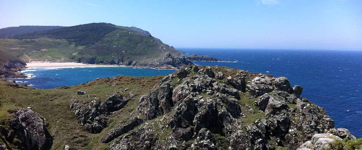
At the summit of Castelo Point and entering the sea, we find another vestige of history many centuries ago, nothing less than the Iron Age: Castro de Castromiñán. When we are approaching, we distinguish perfectly under the bushes of gorse the two walls that surround it. At first glance it seems to us an inhospitable place but, as in all the castros, the location is not accidental, taking advantage of the water of several springs that arise there. Our ancestors managed to create an artificial tower in the highest part to protect themselves from the colder winds. From the heights they could control everything without being seen and, surrounded by cliffs, they didn’t need any other defense.
Next to it, Gavioteira Point, another challenging cliff. Its name does not surprise us … what better place to live being a seabird than these lonely places. From there we can perfectly see our next destination: the Arnela Beach and the cliffs of Cabo da Nave.
After walking the entire cliff, we arrive at forest of Arnela, the only shade of the whole stage and a good place if you need a stop. Arnela Beach, completely isolated and quite protected, appears as a haven of tranquility between the cliffs of Castelo Point and the Cape of the Nave. Surrounded by a beautiful dune complex, it is a very dangerous beach for swimming.
On the path that borders the Arnela Beach we reach the first cliffs of the Cape of the Nave. This whole stage has taken us along a rugged and rugged coast, which we have been going through the heights, but this section has no comparison. For two and a half kilometers, we will progressively climb up a path, from a height of 40 meters to 220 meters from the antennas of Cape of the Nave. A hard section that we will have to walk with a lot of tranquility and that has difficult escapes. From the path we see all these wild cliffs that plummet towards a brave, wild, dark ocean … The trail is spectacular and we are back on a mountain trail at sea level
In the second part of the section, the path, although still steep, is easier to walk. After this hard walk, we arrive at the antennas of the Cape of the Nave, where we will take the opportunity to rest a little before facing the last kilometers of this Camiño dos Faros. The views from this roof are spectacular. The mountain that plummets, the beach of Mar de Fora and the imposing Monte Facho, which hides at the end our goal: the Fisterra Lighthouse.
With its five hundred meters in length and somewhat more collected than the previous ones, the Mar de Fora Beach is oriented to the open sea, ideal for walking and breathing that fresh smell that floods everything, but very dangerous for swimming. Every year someone drowns.
From there, along the cobbled road, we arrive at the Bar da Insua, where we make the last and necessary refreshment stop at O Camiño dos Faros. This bar is one of those little things that we love so much to give life. You can see the mural painted by Teresa Candal and, although the desire to arrive is many, we will rest and we will all arrive together at the end, the mythical Fisterra Lighthouse.
We begin our quiet ascent to Monte Facho along the Camiño da Insua, an old path encased among rocks. Monte Facho is a place of legend. In Duio numerous archaeological remains have been found indicating that there may have been Dugium, the great city of the ancient Celtic settlers of these lands, the Nerios. And that here, on top of Monte Facho, they had their altar of the sun: Ara Solis, where they performed their pagan rites of worship to the king star.
Monte Facho has also been, since time immemorial, a key place in navigation. Before the construction of the lighthouse in 1853, at the top bonfires were lit to guide the ships that crossed these difficult seas or to warn the cities, by lighting other facs, of enemy incursions on this coast. A few hundred meters offshore and challenging, we see the islet of O Centolo. This 25 m high rock is struck again and again by the strong sea forming a perfect habitat for the rich barnacles that are raised there.
The last climb, very steep and with stony terrain, is the final gift of this trail, which tells us for the last time that something wants something costs. Upon reaching the top, the prize is not small: the first views of Faro Fisterra, which we reached by a completely different path from the rest: O Camiño dos Faros. The vision presented impresses us, as I had done with the Romans and pilgrims who arrived here at all times. At our feet, the vastness of the Atlantic Ocean is crossed by thousands of boats that cross this sea corridor every day.
The first order Fisterra Lighthouse was built in 1853 to signal this key geographical point in navigation. The octagonal stonework tower measures 17 meters and its lantern, located 138 meters above sea level, reaches more than 30 nautical miles. Originally it worked with oil lamps, later switching to incandescent lamps, which emit a flash every 5 seconds.
The set is completed with the Semáforo building, built in 1879 to signal the navy. At present, after a rehabilitation, it is a small and curious hotel at the end of the earth. If we look to the south, the entire Corcubión estuary, the Lobeira Islands and the imposing Monte Pindo complete this natural viewpoint.
And here, in the Finis Terrae of the Decimo Junio the Gross, is where O Camiño dos Faros ends that directed us to the trasnos throughout this Death Coast. A Camiño dos Faros that runs through many different landscapes, always facing the sea and facing the west. Lighthouses, beaches, dunes, rivers, cliffs, forests, estuaries with a large number of birds, granite seas, castros, dolmens, fishing villages, viewpoints to the sea that breaks in all possible ways, sunsets … In summary, a hiking route as few and that will take the hiker to a world of unique sensations that can only be enjoyed on this Costa da Morte.
Route Planning
| Km Stage | Point | Height (m) | Km Total |
| 0,0 | Lires | 37 | 100,2 |
| 1,4 | Lires Estuary | 7 | 101,6 |
| 1,8 | Lires Beach | 26 | 102,0 |
| 3,5 | Cliffs of Lagoa | 87 | 103,7 |
| 5,1 | Cliffs of Mexadoira | 35 | 105,3 |
| 6,8 | Rostro Beach | 5 | 107,0 |
| 8,6 | Rostro Point | 30 | 108,8 |
| 9,8 | Castro de Castromiñán | 64 | 110,0 |
| 11,6 | Arnela Beach | 84 | 111,8 |
| 12,8 | Cliffs Cape of Nave | 105 | 113,0 |
| 14,7 | Antennas Cape of Nave | 234 | 114,9 |
| 17,6 | Mar de Fora Beach | 7 | 117,8 |
| 18,5 | Bar da Insua | 72 | 118,7 |
| 18,7 | Insua Path | 89 | 118,9 |
| 20,8 | Mount Facho | 228 | 121,0 |
| 22,0 | Fisterra Lighthouse | 118 | 122,2 |