
ROUTE RONCUDO – LAXE
MONDAY, MAY 26
This stage takes us through an infinite variety of landscapes. We begin by descending the cliffs of Cabo Roncudo, where the sea does not stop snoring, and then we enter the interior of the estuary. The Monte da Facha and the entire Estuary of the Anllóns River with the dunes of A Barra complete a path that will leave you with your mouth open. In the second part we will visit the beautiful coast of Cabana, full of furnas and wonderful places to get lost. Thus we will arrive at Laxe, where we will get our feet wet crossing their beach to finish the stage.
Difficulty HIGH
20.1 kilometers
8 hours
+- 900 m/slope


Make your reservation for the GWF Camiño dos Faros Program

The small village of Roncudo shows us an architecture based on the same stone and totally adapted to the wind and the storms, with large stone walls that have to protect these people from the harsh winter. Small groupings of houses in the hardest and most isolated of this Finis Terrae, a way of life that makes us imagine what life would be like decades ago, without light, without communications, in the midst of the storms … can you imagine it? In the leisurely walk through the village we do not stop thinking about that, as they would manage under those conditions and without today’s communications.
The large number of granaries testify that the economy was, and still is, totally subsistence. It is a beautiful village, this Camiño dos Faros surprises you at every step.
We cross the village and go down to the lighthouse in a totally different way from the rest of the routes. From the village of Roncudo we cross the wind farm and then descend to Laxe das Pesqueiras along a fairly technical path, where it is sometimes difficult to maintain balance.
We continue along the small path between gorges and cross the ledges that get into this sea of Roncudo. There is a time when we can see the three lighthouses of these early stages, a unique case all the way. On our right we see those of Punta Nariga and the Sisargas Islands … and, on the left, the Roncudo Lighthouse, which we will reach in a short time. Large cliffs, witnesses of stories of shipwrecks and huge caves, such as the Furna da Fuxisaca, which are slowly taking us to the lighthouse.
The name of Faro Roncudo comes from the hoarse noise the sea makes when it breaks on these cliffs. The simplicity of the lighthouse, built in 1920 and with a height of 11 meters, and the surroundings of granite stones and a rugged landscape, make it even more mysterious. The panoramic views of the Ría de Corme and Laxe complete the set.
That force of the sea and the characteristics of the waters make these rocks the ideal place for the famous Roncudo barnacle, considered the tastiest of Galicia and that is extracted by the risky “percebeiros” that fight in these extreme conditions, of which sometimes they go wrong, as indicated by the two crosses that are seen next to the lighthouse. It is here in Roncudo where many other ships that sailed through these waters and were not able to survive A Costa da Morte ended their days. And many of those shipwrecks gave names to the stones surrounding the lighthouse. Under the crosses is the Petón do Millo … why? because a ship loaded with corn was shipwrecked there and fed the entire population for months.
The best barnacle we know is the Percebe do Roncudo. In recent years, a rational plan for the extraction of this precious delicacy has returned the wealth of yesteryear. Our friend Suso Lista explains his secrets here: «The good barnacle is the one that is as tall as it is wide, let us understand, the one that most resembles a big toe. The barnacle is like eating a piece of the ocean, just like that. You close your eyes and in the ocean there is everything: there are algae, fish, lobsters, dolphins, air… It is a drink of ocean one hundred percent »
Since 1992, on the first Saturday of July, the celebration-exaltation of this product is celebrated, which makes Corme a place known throughout the world.
From the lighthouse begins another coastal section that will take us through the furnas on this side of the estuary. O Camiño dos Faros gets into the Ría de Corme-Laxe and everything changes again, with softer landscapes than those we have traveled. After a small stretch of asphalt we reach Corme. Its current tranquility contrasts with the activity in the early twentieth century, when Corme is considered the first port of Spain in timber exports. Corme is land of sailors, who sailed in all the seas of the world. Corme is perhaps the town that, in proportion to its number of inhabitants, has given more captains to the history of navigation.
In addition to this wooden traffic, the fleet had numerous merchants, tarrafas and some fishing boats. In those years there were also several canneries and the population increase was notable, with 2978 inhabitants according to the 1920 census. With the arrival of the civil war and other complementary factors, there will be a crisis in fishing and the consequent decline of the population
From here, the beaches of Corme, Monte da Facha and Valarés and its pine forest await us. The panoramic views of the estuary of Corme-Laxe that we will find will surprise you.
Osmo Beach is the most used in the summers of Corme by a family tourism that seeks tranquility and take a bath in these rather fresh waters, like all the rest of the estuary. It has showers, lifeguard services and a fountain. At the end of the beach there is a curious furnace.
Ermida Beach is the largest beach in Corme. Located 1 km from the town center, along the road that leads to Gondomil. It has parking and has lifeguard services. In it, in addition to its dune complex, we can see the small Island of Estrela, scene of multiple legends and where there are the remains of a small castro and an old chapel dedicated to the Virgin of the Estrela.
We cross the beach and continue the path costing towards the Río Covo Beach, another corner of A Costa da Morte as beautiful as unknown to the vast majority.
We leave Río Covo along a path that is mid-slope, narrow and irregular, which leads us to Punta do Canteiro. From there begins the ascent of this section, very short but demanding (70 m, 22.7%), which takes us to A Parede. As always in this Camiño dos Faros, all climbs are rewarded and, upon arriving at A Parede, we can enjoy a wonderful panoramic view from the balcony that forms this huge rock. The stop is a must. To the right, Corme, opposite Laxe and the coast of Camariñas to Monte Branco, half of this Camiño dos Faros. On the left, Cabana and the mouth of the Anllóns River … all the way that awaits us … Spectacular!
From here, we begin the path that, in continuous descent, takes us to Valarés Beach, which we reach by the iron spider that is on the edge of the pier. This beach, located inside the estuary at the foot of Monte Blanco is one of the most visited on the Costa da Morte. The careful pine forest that surrounds this beach is the perfect place to have a picnic and a stop on our way.
The history of Valarés is also the history of Titania S.A., a Galician mining company created in 1936 and extinguished in the 1960s, and dedicated to the exploitation of titanium in Valarés. The mine was discovered in 1935 by geographer Isidro Parga Pondal, and was a great economic support for the life of the region of Corme and Laxe in the tough Spanish postwar period. The company had an economato, good salaries for the time and decent working conditions.
Today remains of the port are preserved and you can hardly see the pools where the rutile (titanium oxide) was separated from the sand of the beach. In addition to titanium, the sulfur brought from other mines was tried, but they stopped doing so because many workers lost their hair and had spots on their skin. In a short time, the titanium business was over and in 1960 it was closed. Here in Valarés, we end this stage along the Corme coast where we have been breathing sea all the way.
If we continue to Ponteceso we would see the Anllóns River flowing into the estuary and forming a meander, which creates these immense Dunes of Barra, of fine sand and continuosly molded by the action of the wind that moves the grains at will, drawing a spectacular landscape. It is the desert of the trail and an extremely environmentally sensitive area.
After passing the dunes, we walked along a path next to the river. This estuary is the habitat chosen by a multitude of birds, such as the plover, the pout or the mallard to spend long periods. We recommend doing this section with binoculars and you can use the observation cabin installed there. At the end of the path, we turn to the right to, after crossing the Xunqueiral go along the Malecon do Couto track towards Ponteceso.
PART TWO: REBORDELO-LAXE
From Taboído we begin this second part of the stage that will take us along the coast of Cabana until we finish at the wonderful beach of Laxe. After a small part of asphalt, a crossing to the left takes us to a path through the forest on the way to our natural habitat … the sea.
To the right, Punta do Padrón and Furnas dos Corvos and Valouta, with Monte Branco in the background. Opposite, all the estuary we have already walked, with Corme and the Roncudo Lighthouse. A dirt path and easy to walk, but always with the difficulty of going along a coast full of caves.
We surround the Furnela Mundiña. There existed a lighthouse in the past, now it is a private residence. Opposite we see the islet of Castelo. It is worth the stop to see the spectacle of the sea breaking. On the other side, Punta do Cabalo and Monte da Insua, with the Laxe Lighthouse. Another very nice section of this Camiño dos Faros.
Rebordelo Beach is located in another virgin environment of the Cabana coast, surrounded by pine and eucalyptus forests. Oriented to the northeast has enough sea, so you have to be careful when swimming. To the left of the beach there is a stream that, in the winter months, forms a curious waterfall.
We leave Rebordelo through the forest that goes over the beach and continue along Punta da Catuxa to San Pedro Beach. Located between two boulders and surrounded by forest, it is another of the small treasures that we can find in Costa da Morte. By a narrow path between pine forests on a coast that continues full of headlands we arrive at Portiño de Figueiras.
A small climb will take us to Punta do Cabalo, from where we have a privileged viewpoint over the entire estuary, in a corner that in spring becomes a beautiful colorful garden above the sea.
Thus we arrive at Punta Rubia and a new landscape appears before us: our goal in the town of Laxe. But before we will still pass through the Coido dos Muiños, a beautiful stew of calm waters where a small waterfall cascade flows, on which two mills are built. In ancient times, the people of the area came to grind and hence the existence of a path, which was hidden among the undergrowth, and that is now where we direct our steps towards Laxe.
Y, cuando pensamos que ya lo habíamos visto todo, cuando recorrimos castros y dólmenes, nos encontramos en la primera finca (propiedad privada pero se ve desde el camino) con este capricho arquitectónica del siglo XXI: La Trufa. Según su creador, el arquitecto Antón García-Abril, La Trufa es una obra anecdótica, por su diseño, su ejecución y su entorno. Es un fragmento de naturaleza construida con tierra, llena de aire. Un espacio dentro de una piedra que se posa en el terreno y que se mimetiza con el territorio. Se camufla, al emular los procesos de formación mineral en su estructura, y se integra con el medio natural al someterse a sus leyes. Es curiosísima, mirad el vídeo o este reportaje …
And, when we think we had already seen everything, we found in the first estate (private property but seen from the path) with this architectural whim of the 21st century: the
Truffle. According to its creator, the architect Antón García-Abril, La Trufa is an anecdotal work, due to its design, its execution and its surroundings. It is a fragment of nature built with earth, full of air. A space within a stone that perches on the ground and that blends with the territory. It camouflages itself, by emulating the processes of mineral formation in its structure, and integrates with the natural environment by submitting to its laws. It’s very curious, watch this video.
We continue our way and arrive at Punta da Area, end of the municipality of Cabana. A stretch of coastline from Taboido to here that shows us a lot of different landscapes.
We arrive at Laxe Beach, which is fully integrated into the town, occupying a large part of the southern coast of the estuary. Its kilometer and a half of fine white sand, to which it adds a wide range of services and a great promenade, make it a perfect beach to enjoy a family day.
On this side of the beach through which we arrived, and due to the influence of the tides, high mountains of sand often form. Reaching Laxe Beach at this end of the stage is another sensation of this route. Walk it slowly and barefoot along the edge of the sea, without hurry to arrive, making all the senses enjoy … it is a gift that can only be offered by O Camiño dos Faros.
At the end of the beach and with very cool feet, we access the Laxe Square, end of this stage that has everything.
Route Planning
| Km Stage | Point | Height (m) | Km Total |
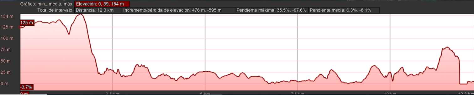
| 0,0 | Village of Roncudo | 125 | 21,9 |
| 0,0 | Roncudo source water (good) | 125 | 21,9 |
| 1,6 | Wind farm | 154 | 23,5 |
| 2,5 | Descent to Roncudo | 31 | 24,4 |
| 2,5 | Mouchón Point | 31 | 24,4 |
| 3,6 | Roncudo Lighthouse | 11 | 25,5 |
| 5,2 | Gralleiras Point | 24 | 27,1 |
| 6,7 | Port of Corme | 2 | 28,6 |
| 7,5 | Arnela Beach | 6 | 29,4 |
| 7,9 | Osmo Beach | 6 | 29,8 |
| 8,8 | Ermida Beach | 2 | 30,7 |
| 9,2 | Island of Estrela | 9 | 31,1 |
| 10,1 | Río Covo Beach | 23 | 32,0 |
| 10,8 | Canteiro Point | 24 | 32,7 |
| 11,6 | The wall | 75 | 33,5 |
| 12,2 | Valares Beach | 6 | 34,1 |
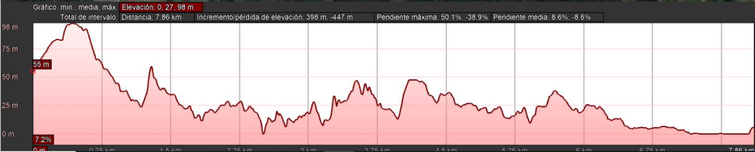
| 0,0 | Taboido | 55 | 34,1 |
| 1,3 | Cave of Mundiñña | 51 | 35,4 |
| 2,5 | Rebordelo Beach | 0 | 36,6 |
| 2,8 | Catuxa Point | 10 | 36,9 |
| 3,1 | San Pedro Beach | 8 | 37,2 |
| 4,1 | Cabalo Point Viewpoint | 48 | 38,2 |
| 4,7 | Rubia Point | 26 | 38,8 |
| 5,3 | Frexufre | 23 | 39,4 |
| 6,0 | Area Point | 26 | 40,1 |
| 6,5 | Laxe Beach | 0 | 40,6 |
| 7,8 | Laxe Square | 6 | 41,9 |