
ROUTE ILLA DE AROUSA (Circular)
MONDAY, MAY 19
A Illa de Arousa is a paradise for the hiker who, on a fairly flat and very diverse route, will discover one by one the secrets of this island that has only been connected to the continent for 35 years. This insular component gives a strong character to its people who, almost entirely, live from mussels and shellfish bats, both on foot and afloat. Beaches of all types, large rocks and the Carreirón Natural Park, which is one of the natural jewels of this estuary.
Difficulty LOW
23.1 kilometers
7 hours
+341 m, -339 m slope


Make your reservation for the GWF Rias Baixas Program
-
 GWF Rias Baixas 1 Pax Shared Double Room975,00€
 -
 GWF Rias Baixas 1 Pax Single Room1.235,00€
 -
 GWF Rias Baixas 2 Pax Double Room1.950,00€
We start from Dock of Xufre, which is the nerve center of the population. There is the fish market and the largest ships, which grow the mussel in the trays that populate the estuary. Since the 50s of the twentieth century, when the first bats appear in Vilagarcía de Arousa, this resource has been increasing until today, that there are about 3300 bats in the Galician estuaries, which produce about 300,000 tons of mussels and give direct employment to about 10,000 people.
The large amount of nutrients in our estuaries, in addition to the native design of the bateas, has led Galicia to be a world leader in mussel production. The bateas are composed of a framework of eucalyptus wood, rectangular in shape and with a float system, from which hang a series of ropes (approximately 500 per batea).
In the process you must first obtain the seed (mexilla) that is torn from the rocks or the ropes themselves to which it adheres during the larval process. Then the stringing is done where, between 10 and 15 kilos of this seed is fixed to the rope through a cotton net, until the mussel already adheres to itself. There he spends between 4 and 6 months fattening and multiplying by 10 his weight until the moment of division arrives, in which the ropes are lifted and the mussels are divided, putting about 40 or 50 kilos of mussel on each rope so that they continue their fattening process between 8 and 14 months, depending on the situation of the batea, the oxygenation of the sea and the amount of nutrients, until reaching 7-10 cm for commercialization.
At the end of the process, when the mussel has reached its commercialization size, it is harvested by lifting each of the ropes with the ship’s crane and is classified in the grills, and then commercialized by one of the three main routes: treatment plants for fresh consumption, canning factories or cookers. As you can see, it is a long and laborious process that feeds many families, since their ownership is very distributed and it is rare to see a family that has more than one or two bats.
We continue our walk along the Xufre Pier and stop to contemplate the small boats, all of the same size and bright colors, with which these hardworking people perform another of the hard offices of the estuary: shellfish afloat. Standing, from the boat, at depths between 3 and 5 meters and using the rake, eucalyptus wood rake with a metal basket at one end, track the sandy bottoms of the estuary to extract clams, cockles and other mollusks.
We continue on our way and arrive at the image of the Virgen del Carmen, patron saint of sailors and object of great devotion in all the coastal towns of Galicia.
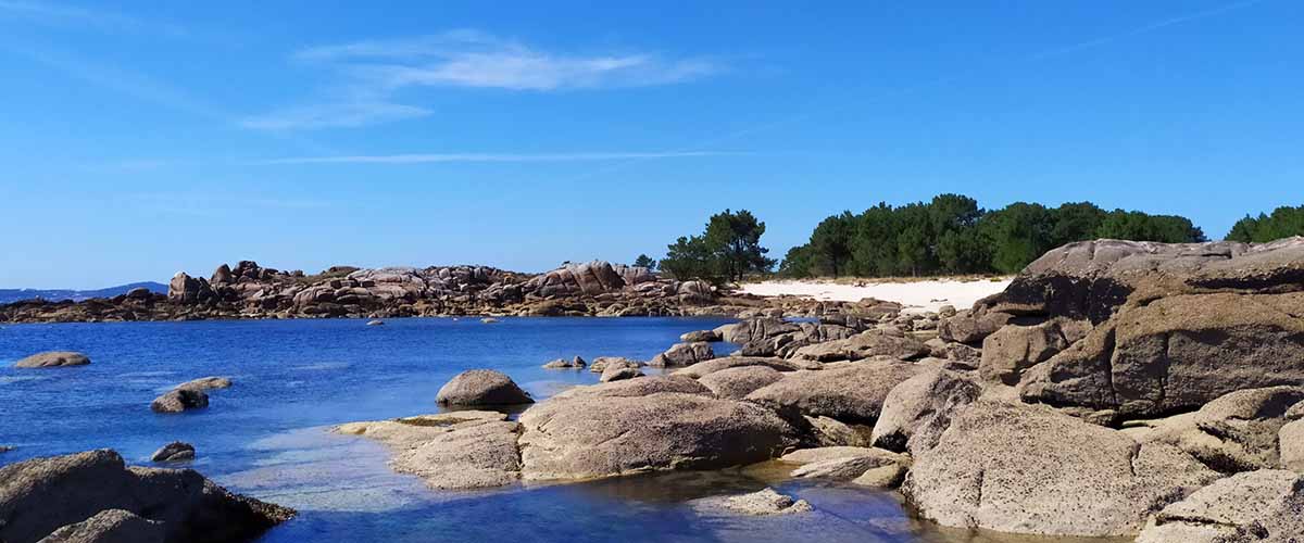
The beginning of the stage is multicolored. We continue along the coastal path over small coves that are interspersed with rock ledges and that leads us through Punta do Campelo, at the north end of the island. Notes to where you aim with the objective of the camera, boats, house facades and the blue of the sea completely fill the plane.
In this part of the walk we can see Aurelio Silva, one of the local companies where the mussel is purged for distribution. The need to purify arises from the habitat and type of food that these mollusks have, filtering water from the trays and thus obtaining nutrients but contaminating them with different products such as bacteria, sands and also toxins. In addition, a bat is not a clean enough place to consider that a simple surface wash is enough. Therefore, it is necessary to carry out a purification process by filtering the mollusks with a completely clean, disinfected and controlled water, in order to get them to release some of the contamination present in them.
The Punta Cabalo Lighthouse is located on a huge rock ledge. It was built in 1852 to signal this northern part of the estuary. It currently houses a restaurant from where we can see one of the most beautiful sunsets of the Rías Baixas. From the rock on which the lighthouse is, we have a wide panorama of Mount Curota with all the towns of Barbanza, from Ribeira to Cabo de Cruz. We also see the polygons of bats and the entrance channel to the Port of Vilagarcía, which houses ships of great draft.
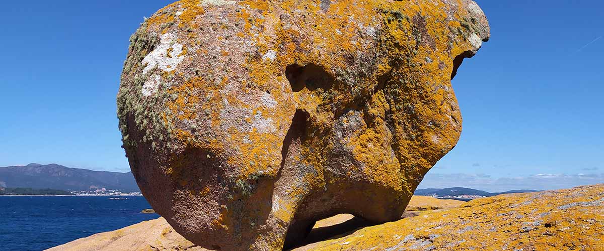
These large rocks with varied shapes are called Cons. Each one has its name and we walking and knowing them throughout the stage.
We leave the lighthouse on the Sualaxe Beach to, just to the left of the beach, take a narrow path that brings us to a huge flat stone.
We arrive at the Area Secada Beach, surely one of the best in the whole area, for its tranquility, its clean waters for the bathroom and the beautiful pine forest that surrounds it, which makes it a very familiar destination in summer. At the end of the beach we arrive at Punta de Barbafeita, another set of large granite stones of the most varied forms. Among others, we can see the Con dos Tres Pés, a unique formation that maintains balance perfectly through its three small feet. Let the imagination fly through so much stone and enjoy once again the magical corners and the wonderful views that this island offers.
We continue the walk along the coast crossing small coves interspersed with rocks that create ponds full of color and life and we reach the wooden walkway, from which we see the entire entrance of the estuary and, in the perfectly defined medium on the horizon, the Salvora Island.
All this technology and way of working in mussel production and in the management of shellfish banks need a lot of research and development. Here is the IGAFA (Galician Institute of Aquaculture Education) that teaches its students to optimize all that wealth and ensure its performance and sustainability. In front of the institute you can see some bats different from the rest, they are the test fields where the main investigations are carried out.
We go back a few meters from the IGAFA to take the path that, through the artificial grass soccer field, will take us to the highest point of the island. We cross the Mount of Bandeira to the Radar installed by Customs Surveillance and that tracks any suspicious movement of boats in the estuary, next to the other 2 located in Riveira and O Grove.
O Con do Forno is the highest point of the Illa de Arousa at 63 meters. It is low height, but the flat configuration of the whole island, offers a great viewpoint with a wide panoramic view of the entire Ría de Arousa. On the top is the image of the Saint.
We walk towards the town to reach another of the key places of the economic development of the island. The Goday Canning Factory was the first one installed in Galicia in 1879, and it was a turning point in the industry, with the passage of the old salting used for fish conservation to the modern canning factory we know today.
Some of the most important changes are a property optimized for production, the Nantes-style sardine is fried before being canned and the customer becomes the national and international consumer market, competing with the big brands. In 1881 King Alfonso XII visited Arousa Island and Mr. Goday’s factory, being so impressed by the modernity of the facilities and the quality of the products made in it, that he named him “supplier of the Royal House.”
The Goday family continued to own the factory until the cessation of their activity in 1961. During all that time it was a source of wealth and work for several generations of families on the island and a reference for the installation of similar factories all along the Galician coast.
As you can see, this stage in the northern part of the Illa de Arousa tells us a story and, in a short space, we have known many of the curiosities of this town one hundred percent sailor.
Next to the Museum of Conservation is the Town Hall and the Pau Pier, a former private dock that was used by the canning factory, from which another walk along the coast begins.
Regueiro Square is another center of the island’s life and the place to celebrate the holidays. The scarcity of land is something inherent to the island, and places like this give a break to all these narrow streets. We continue south and we find the ruins of another canning plant in O Portiño.
The Aceñas Tide Mill is an interesting ethnographic element and shows us that relationship of the islanders with the sea, using the force of the tides to move their gears. When the sea rises a basin is filled, retaining the water, which, at low tide, is thrown into the sea, rotating the mill wheel. There are three wheels on this one, one to grind wheat exclusively and two for corn.
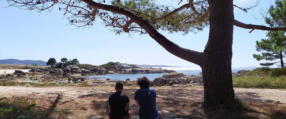
Thus we arrive at the Carreirón Natural Park where, in the forest of its entrance, we can do the rest and picnic before walking the second part of this stage through the Illa de Arousa.
The park has a great variety of ecosystems in a space of two square kilometers, such as dune systems, marshes, bushes, pine forests or all the rich underwater landscape of the island, which covers countless species of wildlife.
The tour begins on a path between the pine forest that brings us closer to Espiños Beach where, if there is low tide, we can see the large areas of intertidal sand that are the perfect habitat for clams, cockles or razors and the livelihoods of many families of the island. We remember that «the sea belongs to everyone, but the seafood for those who work it». The shellfish on foot is usually done by women, who sow these breeding grounds to, after much care and work, collect the seafood with its best size for marketing.
In this very varied and pure ecosystem of the Umia-Grove Intermareal Complex and being an island surrounded by sea in one of the corners of Europe, birds are very present on the island. Species like the common teal, the Mallard or the correlimos, robins, warblers, archibebes, plovers or tarabillas are easy to see in the park. To see without being seen, we have bird watching cabins in some points of the route.
The park is full of small coves, some of them naturist, maintaining that essence of tranquility and nature in which everyone always finds the place. We go through the sand, jumping from rock to rock and admiring the spectacular pictures full of life that nature shows us in the pools of the shore. Any corner is a good plan to stop, breathe and activate the senses. Daisies Beach, Women Beach, Dog Tooth Beach… suggestive names for these small and flirty coves that line the entire park and are divided by the ubiquitous and immense granite stones.
We continue walking and the perspective changes as we focus on the southern part of the estuary: Cambados, the Illa de A Toxa and the entire O Grove coast. At the height of a large fig tree in Eagles Beach, a path that crosses the park inside, returning to the starting point. But we will continue along the coast, crossing the southernmost beaches of the island to complete the tour, which ends at Xastelas Beach, wide and full of shells, which takes us back to the entrance of the park.
From there, a tiled path runs throughout this part of the island, where the campsites, caravan parking areas and several beaches are, with beach bars where you can stop before continuing through the last part of the stage.
Bao Beach is one of the most used on the island. Its proximity to the bridge as well as the large parking lot it has becomes a comfortable option for the families that visit it. Like the rest of the beaches, there is an abundance of shellfish shells, which gives an idea of the richness of all these waters.
On the Bao Beach begins the Island Bridge (Ponte da Illa), a work that was not done until 1985 and that definitely linked the island with the continent, assuming a social and economic advance for its inhabitants, who left behind that past of isolation and inequality that it made more expensive any aspect of their lives. To understand the island’s character we have to realize that until two days ago to go to the doctor or school they had to depend on the weather and a ship that left them in Vilanova. With the bridge the goods were cheaper and the young people have more exits to study and work, greatly improving health care.
Although this isolation also had its good things and it was that it avoided the tourist massification of the island, keeping practically intact all its environmental riches. A massification that, at present, occurs in the summer months and that should be analyzed and corrected so that A Illa de Arousa remains the natural paradise it is. With the construction of the bridge there was also segregation, thus separating from the neighboring Vilanova and becoming a full-fledged municipality in 1997.
We cross the bridge below, we face north and we find the Canteira Beach, where the Canoeing Club is located and we can see some dornas anchored, old sailing boats used by fishermen whose origin could be inspired by Viking drakkars. In recent years, an active association has revitalized this world of dorna and various exhibitions and regattas of ancient dornas are held.
These beaches in this area of the island, although large producers of clam and cockle, are not widely used for swimming. Before arriving at Praia de Aguillón, we take the turnoff to the left that takes us to the urban center. We cross its main street and go through the town center to the Church of San Xulián, built in 1817 in a neoclassical style.
From here we continue through the narrow streets of the island with its typical streets until we return to Dock of Xufre, the end point of this stage and place where there are several bars and restaurants where you can taste all those wonderful products of the estuary we were talking about . A beautiful and fun route through this pearl of the Ría de Arousa, an island that we must respect a lot to maintain its essence and its strong identity.
Route Planning
| Km Stage | Point | Height (m) | Km Total |
| 0,0 | Xufre Pier | 3 | 19,6 |
| 0,8 | Naval Beach | 3 | 20,4 |
| 1,2 | Ruvas Beach | 5 | 20,8 |
| 2,0 | Campelo Point | 5 | 21,6 |
| 2,1 | A Cova Beach | 5 | 21,7 |
| 2,2 | Naso Beach | 6 | 21,8 |
| 2,3 | Os Bufos Beach | 6 | 21,9 |
| 2,7 | Horse Lighthouse | 5 | 22,3 |
| 2,8 | Cons of Lighthouse | 2 | 22,4 |
| 3,0 | Sualaxe Beach | 1 | 22,6 |
| 3,6 | Area de Secada Beach | 1 | 23,2 |
| 3,8 | Con of Three Feet | 1 | 23,4 |
| 4,1 | Barbafeita Point | 4 | 23,7 |
| 4,4 | Barbafeita Beach | 2 | 24,0 |
| 4,9 | IGAFA | 4 | 24,5 |
| 5,9 | Con of Forno | 53 | 25,5 |
| 6,4 | Goday Canning Museum | 8 | 26,0 |
| 6,5 | Town Hall | 5 | 26,1 |
| 6,6 | Pau Pier | 4 | 26,2 |
| 6,6 | Chazo Pier | 4 | 26,2 |
| 7,0 | Regueiro Square | 3 | 26,6 |
| 7,2 | O Portiño | 1 | 26,8 |
| 7,7 | Abilleira Beach | 2 | 27,3 |
| 8,0 | Salt Stones | 4 | 27,6 |
| 8,1 | Gradín Beach | 5 | 27,7 |
| 8,8 | Mallón Beach | 4 | 28,4 |
| 9,5 | Espiñeiro Beach | 3 | 29,1 |
| 9,7 | Con Cerrado Beach | 3 | 29,3 |
| 10,0 | Ruda Point | 3 | 29,6 |
| 10,8 | Tide Mill of Aceñas | 0 | 30,4 |
| 11,4 | Aceñas Beach | 0 | 31,0 |
| 11,6 | Rosa da Mosca Beach | 0 | 31,2 |
| 12,3 | Natural Park of Carreirón | 0 | 31,9 |
| 13,0 | Espiños Pequeño Beach | 0 | 32,6 |
| 13,6 | Espiños Beach | 0 | 33,2 |
| 14,1 | Petóns Beach | 0 | 33,7 |
| 14,6 | Portiña da Revella Beach | 0 | 34,2 |
| 15,0 | Margaritas Beach | 0 | 34,6 |
| 15,4 | Women Port Beach | 0 | 35,0 |
| 15,9 | Agullas Beach | 0 | 35,5 |
| 16,1 | Lonteira Beach | 0 | 35,7 |
| 16,6 | Dente de Can Beach | 0 | 36,2 |
| 17,0 | Arnela Beach | 0 | 36,6 |
| 17,3 | Lombeira Beach | 4 | 36,9 |
| 17,5 | Xastelas Beach | 0 | 37,1 |
| 18,5 | Conserrado Beach | 0 | 38,1 |
| 19,0 | Lavanqueira Beach | 3 | 38,6 |
| 19,2 | Camaxiñas Beach | 4 | 38,8 |
| 19,5 | Camaxe Beach | 4 | 39,1 |
| 20,0 | Vao Beach | 3 | 39,6 |
| 20,5 | Vao Point | 4 | 40,1 |
| 21,0 | Canteira Beach | 1 | 40,6 |
| 21,4 | Riasón Beach | 2 | 41,0 |
| 21,7 | Aguillón Beach | 4 | 41,3 |
| 22,5 | Church of St. Julian | 14 | 42,1 |
| 23,1 | Xufre Pier | 3 | 42,7 |